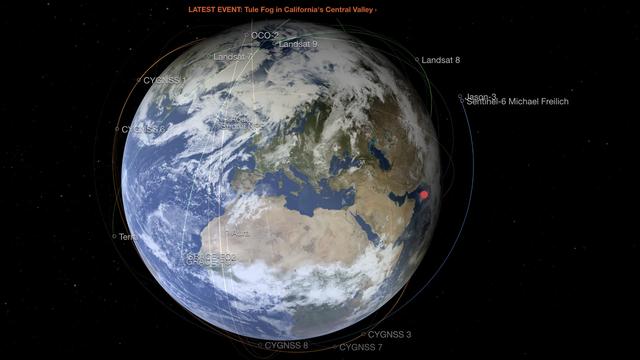
NASA has a site that allows you to see, in real time, the movement of its satellites above the globe. Something to take a little height and observe our planet from every angle.
Aura, Calypso, Suomi… if these names mean anything to you, it's that you probably follow NASA missions with great assiduity. Behind all these names hide the satellites that the American space agency has put into orbit. If you want to know where these dozens of eyes on the world are located and what they can be used for, the Eyes on Earth site is probably for you. It allows you to see their movements in real time and learn more about NASA's various missions. The site received a recent update, the space agency said on November 16, 2021.
Understanding satellite activity to understand the globe
Above a 3D representation of the terrestrial globe, Google Earth style, we can see dozens of satellites dancing above the earth. On November 19, 2021 around 3 p.m., Aqua and Suomi were quietly flying over the North Pole, collecting information on the climate and the evaporation of the oceans.
Because yes, in addition to seeing the NASA machines moving above the planet, the site allows you to learn more about the usefulness of each of these satellites. Just click on it for a quick summary of its mission. It is even possible to see the position of the ISS, if you want to observe the space station with the naked eye. By default, the rhythm of the satellites is accelerated, but it is possible to manage it in the options to obtain a rendering in real time. You can virtually time travel to find out when a particular satellite will pass overhead. The site works impeccably well on mobile (iOS or Android), but offers a little more customization possibilities on the computer.

NASA satellites flying over the globe
Source: NASAThe NASA tool is used for many other things than to observe the ballet of the satellites above our heads. The different visualizations of the globe allow you to see the air temperature, the concentration of carbon monoxide or even the level of the oceans. All the information that is precisely collected by the various NASA satellites. It is even possible to create animations over chosen periods to see the evolution of the data and the globe. For example, we can see the evolution of heat waves (in degrees Celsius or Fahrenheit) over the African continent over the last 10 days (spoiler: it's hot there).
Alert on climate change
"The graphics are as rich as the data, allowing for fascinating dives into science, getting to know the planet better, and learning more about some of the many NASA missions that track the health of the globe. “, indicates the American space agency on its site.
The 3D terrestrial globe is also studded with small red dots representing the latest significant weather or climate events, in order to provide aerial photos of forest fires in Siberia, forest fires in the Amazon or even forest in the United States. If you're in a less apocalyptic mood, you can also observe the development of phytoplankton in different corners of the globe.
NASA's tool is therefore fascinating and a little worrying at the same time, because it allows us to see the importance of space missions and to realize the damage caused by climate change.
Look at the world from space
Medical deserts, public services: what assessment of Macron on rurality?
What is the best Oppo smartphone to choose?
The best phones in 2021 for photos and video
Good Plan: the recap of 4G packages on sale